
Jubbah sits in the protective wind shadow of Jabel Umm Sinman, which roughly translates from Arabic as “two camel-hump mountain.” The hard, black rock of the mountain disrupts wind flow and blocks dunes from forming on its lee side. The area around Jabel Umm Sinman has been at the center of significant climatic and anthropological shifts during the Holocene, a geologic term for the past 10,000 years.

Gold has been found on every continent except Antarctica, but the lustrous yellow metal is not exactly ubiquitous. The element (Au on the periodic table) is actually quite rare, accounting for just one out of every billion atoms in Earth’s crust. But in places such as the Central Aldan ore district in the Russian Far East—where concentrations of the precious metal have been discovered—mining operations are large enough to be seen from space. Central Aldan is one of Russia’s largest gold ore districts, with the mineral occurring in numerous deposits, or “lodes,” in the fractured rock.
Along with the plentiful harvest of crops in North America, one of the gifts of autumn is the gorgeous palette of colors created by the chemical transition and fall of leaves from deciduous trees. It is an aesthetic wonder from the ground, from the mountaintop, and from satellites. The folded mountains of central Pennsylvania were past peak leaf-peeping but still colorful when the Operational Land Imager (OLI) on the Landsat 8 satellite passed over on November 9, 2020. The natural-color images above show the hilly region around State College, Pennsylvania.
With an elevation of 4462 meters (14,639 feet), La Malinche volcano in central Mexico soars above the patchwork of cities, farms, and forests in the surrounding lowlands. Montane grasslands and shrubs dominate at the highest elevations, the heart of La Malinche National Park and the coolest part of the eroded, dormant volcano. At lower elevations, a ring of pine, oak, and alder forests covers the mountain’s middle slopes before transitioning into a tapestry of farmland, villages, and narrow stream valleys called barrancas.
Nearly every summer, colorful blooms of phytoplankton flourish in the Baltic Sea. And nearly every summer, satellite images detect art-like patterns as the phytoplankton trace the sea’s currents, eddies, and flows. But like the whorls of fingerprints, no two phytoplankton blooms are exactly alike. These natural-color images, acquired on August 15, 2020, with the Operational Land Imager (OLI) on Landsat 8, show a late-summer phytoplankton bloom swirling in the Baltic Sea.

Red-tinted sands and dark green braided streams provide a colorful contrast within Australia’s Channel Country. As the International Space Station (ISS) was passing over southwest Queensland, an astronaut took this photo of the Cooper Creek floodplain. The Barcoo and Thomson rivers flow southwest and converge north of the town of Windorah to form Cooper Creek, a major river system that flows toward Lake Yamma Yamma and Lake Eyre (both outside this frame).
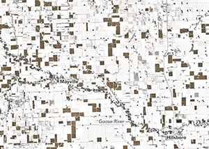
In the wake of a potent winter storm in late November in the U.S. Midwest, an unusual pattern turned up in satellite imagery. A network of brown squares contrasts starkly with the otherwise snow-white landscape of eastern North Dakota. Daryl Ritchison, director of the North Dakota Agricultural Weather Network, noticed the phenomenon and posted an image on Twitter. He noted the brown squares have a simple explanation.

Every summer, vast expanses of the Canadian prairie in Saskatchewan, Alberta, and Manitoba turn a bright shade of yellow. The reason: canola fields reaching peak bloom. The Moderate Resolution Imaging Spectroradiometer (MODIS) on NASA’s Terra satellite captured this image of yellow-tinged fields stretching across the three provinces on July 22, 2019. A day later, the Operational Land Imager (OLI) on Landsat 8 acquired a more-detailed view of canola in bloom near Regina, Saskatchewan.
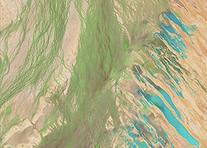
The Lake Eyre Basin in the interior of Australia is among the driest places on the continent. With less than 125 millimeters (5 inches) of rain falling in this area each year, the streams and creeks that drain into Lake Eyre—the lowest point in Australia—are usually bone dry, barren, and brown. Occasionally, the channels do fill after heavy downpours—and create a carpet of green. The Operational Land Imager (OLI) on Landsat 8 observed this transformation in a series of false-color images (bands 6-5-3) acquired between February 24 and April 25, 2018. With this band combination, flood water appears light blue. Vegetation is light green.
The sparsely populated Gran Chaco plain in South America is home to a dry forest of thorny trees, shrubs, and grasses. The second largest forest in Latin America—behind only the Amazon rainforest—stretches across parts of Paraguay, Argentina, and Bolivia and supports thousands of plant types and hundreds of species of birds, mammals, and reptiles. However, the region also has one of the highest rates of deforestation in the world. Observations by Landsat satellites indicate that roughly 20 percent—142,000 square kilometers (55,000 square miles)—of Gran Chaco’s forest has been converted into farmland or grazing land since 1985.

Indonesia’s Mount Sinabung has been sporadically active since 2010, following four centuries of quiet. On February 19, 2018, the stratovolcano on the island of Sumatra erupted violently, spewing ash at least 5 to 7 kilometers (16,000 to 23,000 feet) into the air over Indonesia. At 11:10 a.m. local time (04:10 Universal Time) on February 19, the Moderate Resolution Imaging Spectroradiometer (MODIS) on NASA’s Terra satellite captured a natural-color image of the eruption, just a few hours after it began. According to reporting from the Associated Press, the erupting lava dome obliterated a chunk of the peak as it erupted.
Wild ginseng is an inconspicuous understory plant that grows in shady, moist hardwood forests in Asia and North America. In many Asian cultures, ginseng is thought to have curative properties, a long-held belief that has driven demand so high that it is rare for the plant to be found in the wild in most of Asia. Instead, a multi-billion dollar market for farmed ginseng has emerged. In some parts of China, ginseng farming is easily visible from space. On September 25, 2017, the Operational Land Imager (OLI) on Landsat 8 captured this image of purple and yellow shade covers for ginseng crops amidst browning hills and farmland in Heilongjiang province in northeastern China.
This portion of the Central Siberian Plateau lies within the Arctic Circle, where air temperatures remain below freezing for most of the year. Much of the landscape is covered in permafrost that can stretch tens to hundreds of meters below the surface. There are different levels of intensity, but this area generally has permafrost coverage for 90 percent of the year. The land does occasionally thaw, and cycles of freezing and thawing are known to create polygon, circle, and stripe patterns on the surface (referred to as “patterned ground”). In the case of the images above, the stripes could be elongated circles stretched out on the slopes by such thawing cycles.
